


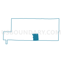
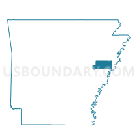
TUNI PCT 16, St. Francis County, Arkansas
About
Outline

Summary
| Unique Area Identifier | 527986 |
| Name | TUNI PCT 16 |
| County | St. Francis County |
| State | Arkansas |
| Area (square miles) | 19.90 |
| Land Area (square miles) | 19.89 |
| Water Area (square miles) | 0.01 |
| % of Land Area | 99.95 |
| % of Water Area | 0.05 |
| Latitude of the Internal Point | 34.95175620 |
| Longtitude of the Internal Point | -90.72427910 |
Maps

Graphs
Select a template below for downloading or customizing gragh for TUNI PCT 16, St. Francis County, Arkansas


Neighbors
Neighoring Voting District (by Name) Neighboring Voting District on the Map
- BONAIR PCT 17, St. Francis County, AR
- MADISON COUNTRY PCT 15, St. Francis County, AR
- MADISON TWP PCT 24, St. Francis County, AR
- MADISON TWP PCT 25, St. Francis County, AR
- Union Voting District, Lee County, AR
Top 10 Neighboring County Subdivision (by Population) Neighboring County Subdivision on the Map
- Madison township, St. Francis County, AR (17,247)
- Franks township, St. Francis County, AR (922)
- Union township, Lee County, AR (274)
Top 10 Neighboring Unified School District (by Population) Neighboring Unified School District on the Map
Top 10 Neighboring State Legislative District Lower Chamber (by Population) Neighboring State Legislative District Lower Chamber on the Map
Top 10 Neighboring State Legislative District Upper Chamber (by Population) Neighboring State Legislative District Upper Chamber on the Map
Top 10 Neighboring 111th Congressional District (by Population) Neighboring 111th Congressional District on the Map
Top 10 Neighboring Census Tract (by Population) Neighboring Census Tract on the Map
- Census Tract 9606, St. Francis County, AR (8,350)
- Census Tract 9602, St. Francis County, AR (6,372)
- Census Tract 4701, Lee County, AR (2,845)